

Imagine this scenario: autonomous vehicles recently deployed in your city and the first fleets are on the street. In a matter of days, there is a major warehouse fire and as your city responds, first responders need to temporarily shut down streets and quickly establish an emergency response zone. How does your city quickly and efficiently communicate this emergency and the associated street closures with autonomous vehicles operating nearby?
That question is becoming increasingly urgent as autonomous vehicle companies seek to expand into more cities around the world. And it is particularly relevant in California, where new rules now call for AV companies to comply with city-generated geofences around emergency response zones.
Instantly Share an Emergency Zone
With the OMF’s recent Mobility Data Specification (MDS) 2.1 release, cities now have the ability to instantly share the location of an emergency and any associated street closures or advisories that mobility operators are required to follow. This information, shared by the MDS Policy API, is a powerful tool that allows cities’ Computer-Aided Dispatch (CAD) systems to designate a set of streets as impacted by an emergency, affecting autonomous vehicle operations. AVs may be asked to redirect around the impacted area, reduce speed, or limit pick ups and drop offs.
A Timely Opportunity
For autonomous vehicle companies Waymo and Zoox, who are also members of the OMF, the improvements to the MDS Policy API provide a timely opportunity to adhere to the new California regulations in a standardized and scalable format. Today, cities in California share their emergency response data in different ways and in different formats that are cumbersome and typically require human intervention to translate and consume. One city may send alerts via text message, one may share alerts in email or phone call, and another city may share this information on social media. But none of these sources provides data in a standard and easily digestible format. With MDS 2.1, cities can directly and digitally communicate essential emergency response zones to AVs and other mobility providers.
How it Works
When a city’s Computer-Aided Dispatch (CAD) system (the 911 computer system in North America) receives a call for fire or medical aid, the call is translated into MDS with a standardized set of information, including the severity, location, and type of emergency. If applicable, an associated “avoid the area” or geofence is designated. The information is then shared with the AV operators via the MDS Policy API so the AVs can avoid conflicts with the emergency scene and first responders. The system is dynamic and can adjust the size of the geofence as the emergency response expands or reduces, eventually notifying the AV operators with an “all clear” when the emergency response ends and the geofence can go away.
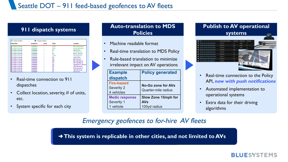
Image courtesy of Blue Systems from the July 9, 2026 MDS Working Group meeting.
View a demo video of the Seattle deployment here.
A Model Partnership For Scaling Solutions
This system was prototyped in a test environment in Seattle, WA in collaboration between the Seattle Department of Transportation (SDOT), Seattle Fire, Blue Systems (SDOT’s software vendor) and the OMF. This collaboration exemplifies how the OMF works at its best: cities identify real-world challenges, develop and test solutions with partners, and contribute what they learn back to an open ecosystem so other communities can build on their work. At a time when transportation technology and digital infrastructure are evolving rapidly, this model allows cities to learn from one another and scale proven approaches rather than each having to solve the same problems independently. By building solutions around shared, open standards like MDS, an innovation developed in one city can become a tool available to cities everywhere.
To learn more about using MDS, visit our GitHub or attend an upcoming working group meeting.

This is the first in a three-part series about the Read more

Technology and data offer new tools to proactively manage curbs Read more
The 1.1.0 release adds new top level APIs, privacy options, Read more