
MDS Architectural Landscape Series
Standards for a Changing World
It’s no secret that our transportation system is changing. In recent years, new modes and services have emerged on city streets fueled by smartphones, new technologies, and a surge of investor interest. Apps and data have altered the way we use traditional forms of transportation, from walking to public transit to driving. And, our travel and purchasing behaviors have shifted in response to this new environment. This rapid pace of change shows little sign of slowing.
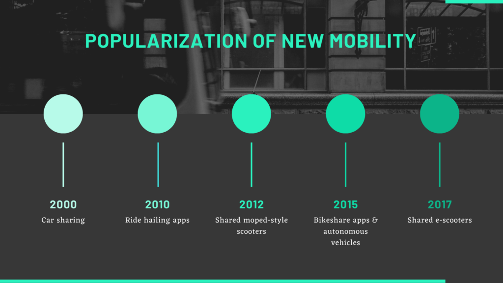
Adoption and popular use of new mobility services in the United States
Despite this tech-infused transformation, the goals of local governments remain consistent. Cities want transportation systems that are safe, equitable, efficient, accessible, and sustainable – all while protecting the individual freedom and privacy of the traveling public. To create a regulatory system that can keep up with the rapid pace of change requires new tools and approaches. Governments must adopt some of the digital, data-driven, dynamic approaches that drive much of the evolution we are experiencing.
In short, we need to learn to speak a common digital language.
A Kit of Parts
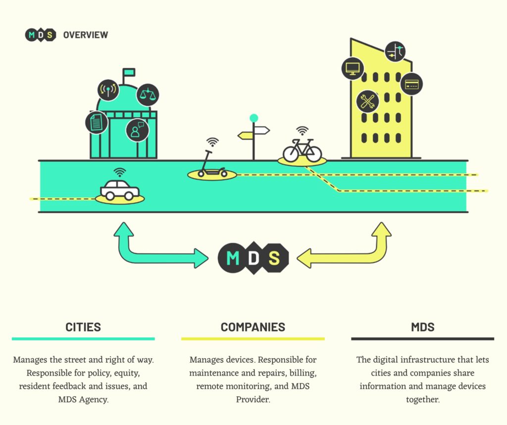
While the goals of government are clear, the tools we’ve been using for the past 100 years aren’t well-adapted to today’s technology-driven mobility landscape. Core to the future of mobility is the development of a set of digital tools for public entities – like city departments of transportation or metropolitan planning organizations – to manage the public right of way. The Mobility Data Specification (MDS) meets this need by serving as a widely-adopted, standardized means of digital communication between the public entities that manage our streets and sidewalks and the organizations that use them to provide transportation services.
Simply put, the vision for MDS isn’t singular or rigid – it’s flexible.
Cities may share many of the same policy goals, but they may take different approaches to how they achieve these goals. MDS does not encode a singular view of how cities operate. It is instead a basic language in which multiple functions of government – policy, management, operations, and mode – can be described and expressed. It is a toolkit from which city governments can pick the right tools for their local context and apply them to advance their goals for their communities.
MDS is a digital kit of parts. It is similar to how the Federal Highway Administration’s Manual on Uniform Traffic Control Devices (MUTCD) defines standards for the physical assets and tools (stop lights, road signs, etc.) used to manage the public right of way. MDS is a set of interconnected technologies that each serve specific public policy purposes, while connecting together to create an interoperable digital framework for understanding and managing a city’s transportation system.
From Micromobility to New Modes and Beyond
While micromobility has served as a successful testing ground for a new model of managing the right of way, the MDS model allows governments to more effectively steward other modes of transportation for the public good. For example, this could include passenger services, aerial urban systems, freight and logistics, and autonomous vehicles. The vision for MDS – and open source projects like it – play a key role in the economic landscape, giving governments the capacity to say “yes” to new business models, modes, and technologies to deploy and scale. The overall vision for MDS is a future where cities around the world have the tools to be good stewards of public streets, and encourage and support changes to transportation that improve urban quality of life.
—
The Open Mobility Foundation (OMF) community – our Board, staff, and members – set out on an ambitious mission this year: to define the growth trajectory for the Mobility Data Specification (MDS), outlining a product strategy and roadmap while defining the development process into the future.
The result was a comprehensive document we call the MDS Architectural Landscape. This post is the first in a three-part series about the architectural landscape where we will explore the vision for MDS. In the future, we will discuss what it means to co-create in an open source environment, and why open source projects are good for public and private sector organizations – and the people they serve.

Learn more about how OMF's unique open source model works Read more

How the Mobility Data Specification evolves to incorporate the best Read more

After two years of pioneering work, here is what we Read more