
City Streets: An Ever-Changing Environment
Whether they’re handling an emergency or just a planned road closure, cities are using the Mobility Data Specification (MDS) to make real-time changes and measure compliance in a constantly evolving environment.
Large scale, public events present unique challenges in urban mobility. From sporting events to concerts and even protests, events often require street closures and close management of transportation. Officials are tasked with ensuring that attendees can get to and from the event, while also allowing the general public to get around safely. While cities rise to meet these challenges regularly, the increased popularity of shared e-scooters has introduced a new element in the form of dockless mobility. This new mode has come with new challenges, but also represents opportunities for cities to work with providers to meet shared goals. MDS allows cities to implement regulations efficiently, measure compliance, and better understand demand for emerging forms of mobility.
Solutions for Managing the Public Right of Way
Enter: geofencing. This solution is aimed at enforcing street closures while also keeping the public right of way free of street clutter that can cause accessibility issues. In the City of Chicago, for example, 2019 pilot terms required that each e-scooter have the functionality to decelerate and ultimately stop within a quarter of a mile outside of the designated pilot area or other areas as designated by the city. They put this solution to the test during two major events last year: Pitchfork Music Festival and Riot Fest.
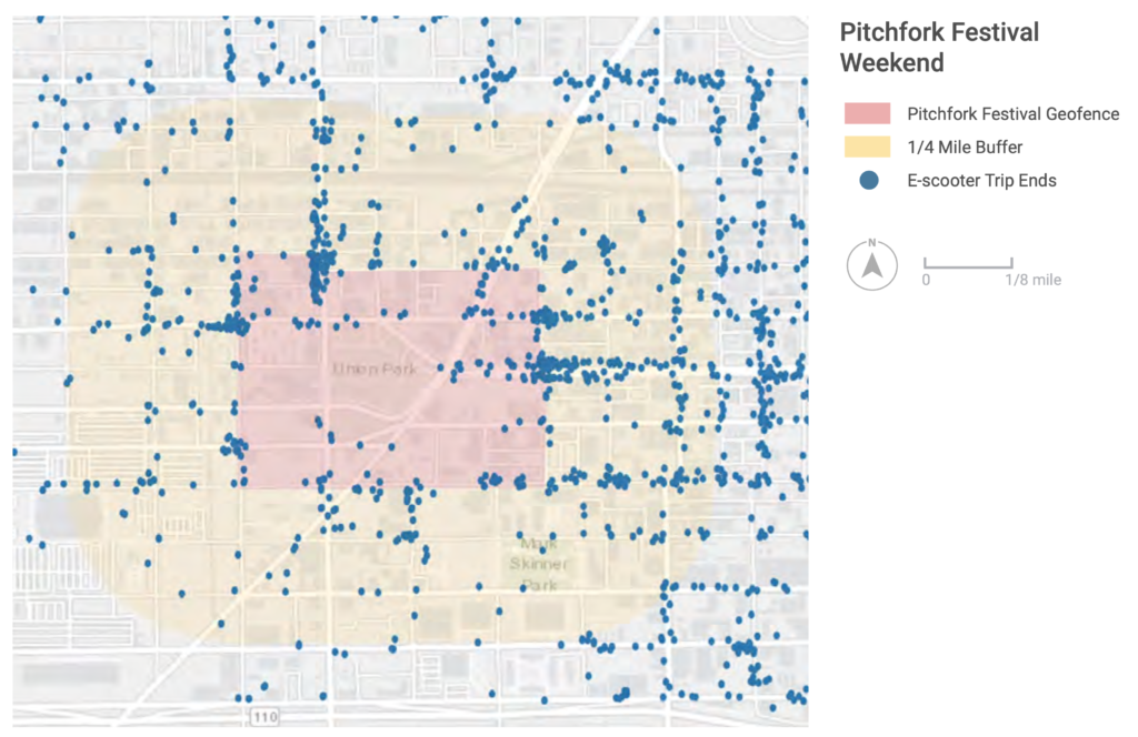
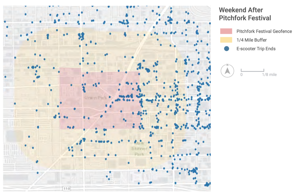
E-scooters were not allowed within a geofence defined by the city on the weekend of the Pitchfork Music Festival. The maps shown here illustrate the geofence around Union Park – the event’s venue – on the festival weekend and the following weekend. The neighborhood around the festival was one of the highest e-scooter usage areas and saw even higher demand during Pitchfork. Also, it’s clear that e-scooters played a role in transporting attendees to the festival, which may be useful for planning transportation options for future events.
Through the Policy API, MDS allows cities to communicate geofences in a format designed to be consumed digitally directly by providers. Rather than a city agency sending an email, for example, providers can instead query the Policy API to get information about local rules that may affect the operation of their mobility service. This improvement to MDS means dynamic events are even easier to manage between regulatory agencies and mobility providers.
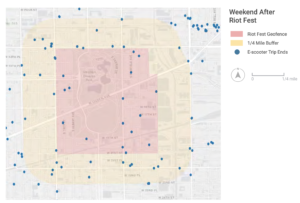
Using MDS to Measure Compliance
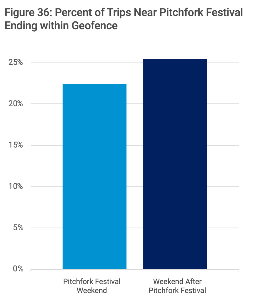
MDS can also be used to monitor compliance, which is exactly what was done in the case of Chicago during their 2019 pilot. The illustration here compares the number of trips ending within the geofence during Pitchfork and the weekend after, and shows that overall, more trips ended within the geofenced area when the restriction was in place than the next weekend when the geofence was not active.

Despite increased numbers of trips ending in the geofenced area during the festival, comparing the number of trips that ended within the geofence to the trips that ended in the surrounding neighborhood shows that the geofence was moderately successful in managing the influx of e-scooter demand. Cities can use this data to work with operators to improve their compliance with geofencing.
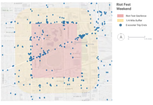
E-scooters were also not allowed within a geofence defined by the city on the weekend of Riot Fest. Comparing Pitchfork and Riot Fest, it is clear that Riot Fest occurs in a part of the city that had lower overall e-scooter usage than Pitchfork. Riot Fest is later in the summer than Pitchfork, and the compliance with the geofence improved. While the number of e-scooter trips to the neighborhood more than doubled during the weekend of the festival compared to the following weekend, the share of trips ending within the geofenced area was cut almost in half.
Between digitally-expressing policy and the ability to measure compliance, MDS plays a critical role in helping cities and mobility operators respond to dynamic events on city streets. Learn more about which cities are using MDS for this purpose by taking a look at our use case database.


This is the first in a three-part series about the Read more

Building on the best practices and policies of cities using Read more